
Mountain Climbing in Turkey
Mountain climbing in Turkey provides exceptional and intriguing opportunities for those who love the sport, both in winter and for mountain hiking and climbing. With its lush forests, abundant flora and fauna, diverse wildlife, and mountains with varying heights and rich geological structures, Turkey attracts many tourists from around the world every year for mountain climbing and hiking.
Application for Permission to Climb Foreign-Owned Mountains
- Applications from abroad are transferred to the Ministry of Foreign Affairs through our foreign representatives.
- Foreign nationals residing in Turkey apply directly to the Ministry of Foreign Affairs through their representative, or if they have no representative, directly to the Ministry of Internal Affairs.
- Travel agents in Turkey forward the requests of foreign nationals who apply to them to the Ministry of Culture and Tourism. Application for Permit to the Ministry of Culture and Tourism The travel agent should inform the Ministry of Culture and Tourism of the following information about the applicants for climbing the mountain. Information to be reported for applicants:
- Name-Surname
- Nationality
- Passport Number
- Date of Birth
- Date of Climbing-Descent
- Which of our foreign representations should take the necessary visa -Exit route Applications can be made by fax to 0.312.212 85 97 or by mail to the General Directorate of Promotion of the Ministry of Culture and Tourism. For information: 0.312.212. 83.00 / 2822 or 2823 Address: Ministry of Culture and Tourism of the Republic of Turkey Promotion General Directorate Ismet Inonu Boulevard No: 5 Floor: 8 Emek, Ankara
- Permission requests from abroad should be made at least 2 months before the climbing date, and permission requests from within the country should be made at least 1 month in advance, and a visa appropriate to the purpose should be obtained.
- Foreigners who have a residence permit valid for at least 6 months in Turkey do not need a visa appropriate to the purpose.
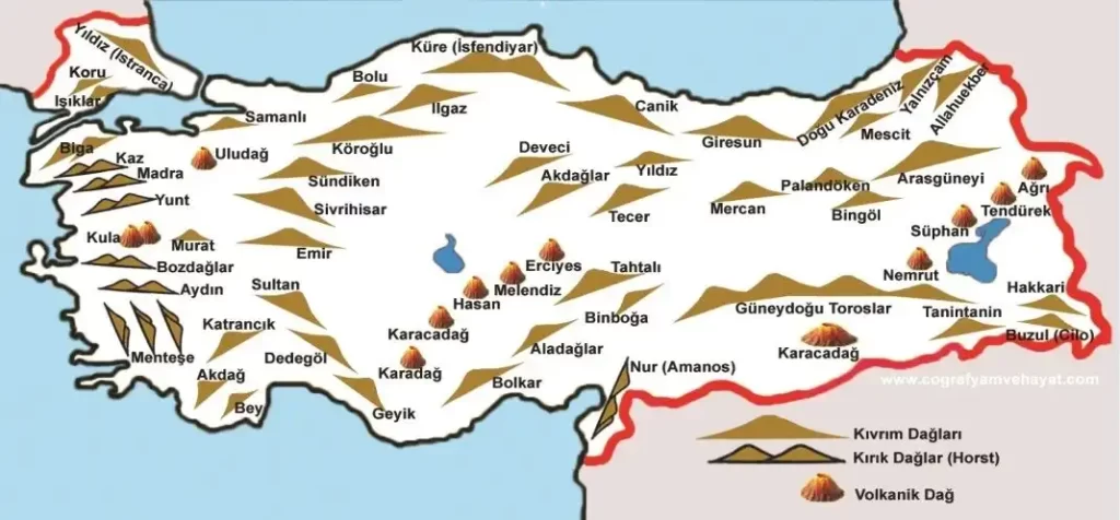
Types of Mountains in Turkey
Turkey, which is said to become mountainous from north to south, is surrounded today by the North Anatolian Mountain Ranges, Inner Anatolian Massifs, South Anatolian Mountain Ranges and South Eastern Anatolian Mountain Ranges. The Istranca (Star) Mountains (1000 m), Bursa Uludağ (2543 m), Bolu Köroğlu Mountain (2400 m), Ilgaz Mountain (2587) and Karagöl Mountains (3100 m) are in the North Anatolian Mountain Ranges, Erciyes Mountain (3917 m), Hasan Mountain (3263 m), Büyük Aladağ (3837 m), Suphan Mountain (4058 m) in the Inner Anatolian Massifs, and Nemrut Mountain (3222 m), Cilo Mountain (3756 m) and Ararat Mountain (5137 m) in the South Eastern Anatolian Mountain Ranges.
The Mount Ararat – Ağrı Dağı
Ağrı Dağı is the largest mountain in Turkey and is a legendary mountain due to its geological location and being the home of Noah’s Ark after the Great Flood. The mountain, which is mentioned in the holy books, has many names in different languages, including Ararat, Kuh-i Nuh, and Cebel ul Haristir. The first ascent of the mountain, which Marco Polo said could never be climbed, was made by Professor Frederik Von Parot on October 9, 1829. The first winter ascent was made by Dr. Bozkurt Ergör, a former president of the Mountaineering Federation, on February 21, 1970. Thousands of mountaineers visited Ağrı Dağı in the 1980s. Climbing the mountain was banned in 1990, but the ban was lifted in 1998 after the Mountaineering Federation allowed a group of mountaineers to climb it.
Height: 5137 m.
Location: Rises near the Iranian border in Eastern Anatolia (between the Aras and Murat rivers)
Best time for climbing: The most suitable months for climbing are July, August, and September. Winter climbing is challenging but enjoyable. Features: Ağrı Dağı (5137 m.) is the highest peak in Anatolia and Europe. The mountain consists of basalt up to 4000 meters and andesite lavas, which show its volcanic features. The mountain has a snow-covered peak. Serdarbulak plateau and the Little Ağrı Mountain (3896 m.) are located on the eastern side. The height, glaciers, people, different structural views, grasslands covered with snow up to the snow line, and mountain meadows give Ağrı Dağı an interesting and attractive appearance.
Transportation and Accommodation: The Trabzon-Erzurum-Tehran international road passes through the Ağrı slopes and extends to Iran. There are regular air, rail, and road connections between Ankara and Erzurum. The closest center to the mountain is Doğubeyazıt, which can be reached from Ağrı and Erzurum. There are accommodation and restaurant facilities in the city and surroundings.
Climbing
Materials: Crampons, Rope, Ice Axe, Safety Equipment (Perlon, Ice Screw, etc.) In summer departures: (-5, -10 ºC) durable sleeping bag, parka, windbreaker, other camping equipment, and necessary supplies are required. Mountaineers must start their climb from the following points when climbing Ağrı and Little Ağrı mountains, which are subject to permission for climbing.
Ascents to Ağrı mountain must only be made from the side within the Doğubeyazıt boundaries, following the route of Doğubeyazıt-Topçatan village-Eli Farm.
Ascents to Küçük Ağrı Mountain must only be made from the northwestern route. The south route is the most convenient and commonly used route for communication, transportation, safety, and climbing angle to reach the summit of Ağrı Mountain.
Climbers staying in Doğubeyazıt complete the necessary preparations for climbing and reach Eli village by car. After a water refill, they reach the first camping site at an altitude of 2800 m after a 7-8 hour hike. They spend the night here. On the second day, they reach the second camping site at an altitude of 4200 m after a 4-6 hour climb. Crampons, ice axes, and ropes are required for the summit climb. The summit is reached after 8-10 hours of climbing and they return to the first camping site at 2800 m.
Beydağlar Antalya – Explore the Western Extension of the Toros Mountains
The Beydağlar mountain range, located on the west side of Antalya Bay, extends parallel to the bay in a north-south direction. Some of its notable peaks include Teke Peak, Bakırdağı, Tahtalı Mountain and Kızlar Sivrisi. The highest peak is Kızlar Sivrisi with a height of 3070 meters.
With a clear sky for 300 days a year, you can reach the summit in just one day. The breathtaking view of the sea and Antalya from the top will make all the effort worth it. If you are willing to sacrifice some sleep, you can witness the sunrise from here and be amazed by the brightness of the day.
If you’re up for some paragliding, you’ll be rewarded with stunning views if you catch the right weather. In addition to being a significant mountaineering center, Bey mountains are also an important winter tourism destination.
Height 3070 m. Location The Beydağlar mountains form the western part of the Toros mountains within the borders of Antalya province. They extend along the Mediterranean coast in a north-south direction. They are suitable for travels and hikes all year round, with the best time being April, May and June, excluding winter months.
Features These cliffy mountains consist of limestone rocks and are covered by various forest covers. There are many mountain peaks on these mountains.
Access The best approach for climbing is via Antalya-Kemer or Antalya-Elmalı. Antalya is connected to Istanbul and İzmir by land, sea and air, and to Ankara by air and land.
Climbing The ascent to the highest peak of the Beydağlar, Kızlar Sivrisi (3070 m.), is done from Elmalı. From there, you can drive to the cedar forest covered Çamçukuru meadow. Mountaineers who set up camp here can reach the summit within a day and return. The most interesting hike and climb in the snow mountains is Tahtalı Mountain, with a height of 2360 meters and covered by different types of forests up to 2000 meters. After the forest cover, there are meadows on the mountain. To climb Tahtalı Mountain, you can drive from Kemer to Soğukpınar (Soğucaksu) on the north side of the mountain. You can choose a camping spot there. The ascent to the peak is done along ridges overlooking the Mediterranean. The views and landscapes change every moment during the climb.
Erciyes Mountain – Kayseri
Erciyes Mountain, which has become the symbol of the city and always has smoke and snow on its top, is a huge volcanic mountain with a height of 3916 meters. The mountain, which formed the Peri Caves as a result of the lava it erupted, was so affected by the Mezeke, who lived on its slopes in ancient times, that the Mezeke depicted the Erciyes Mountain that erupted lava from its top on their coins. W.J. Hamilton was the first to climb the mountain in 1837. The first Turk to climb the mountain was Miralay Cemil Cahit Beydir in 1924.
Erciyes is not only a center for mountaineering but also an important winter tourist center in Turkey. You can also watch the magnificent view of the region stretching from Kapadokya to Toroslar if the weather is clear when you reach the summit.
Height 3917 meters
Location It rises in the southern part of Kayseri province in Central Anatolia.
Climbing Time The most suitable time for summer climbing is between May and October. Features A young extinct volcanic mountain, the highest peak in Central Anatolia. There is a 700-meter-long glacier in the north of the mountain. Tekir plateau, located on the east face with a height of 2100-2900 meters, is a winter sports center. The campsite, Çobanini, can be reached by walking approximately 2.5-3 hours in winter after the ropeway. The climb usually takes about an hour from Çobanini to the break stone. The break stone is located at the mouth of Şeytan Stream. From here, the small summit takes about 2-3 hours. There may be a danger of avalanche in the Şeytan Stream in winter. During spring months (May, June), a helmet is required due to rockfall. Skilled climbers can enjoy a climb with ski touring. Transportation and Accommodation Kayseri can be reached by bus, train or plane from Ankara and Istanbul. There is a 100-bed central heating and telephoned mountain house in Tekir plateau. There are various accommodation and restaurant facilities in Kayseri. A 100-bed new and modern hotel owned by the public authority has also been opened in Tekir plateau.
Climbs Equipment
Crampons, rope, ice ax, helmet, various safety equipment (carabiners, ice screws, etc.), camping equipment.
Climbing from Tekir Plateau The safest climb. It goes from Hisarcık to the mountain house 25 km away from Kayseri. The ascent and descent to the main peak can be achieved in 8-10 hours from the mountain house. Climb from the northwest: This is a challenging but enjoyable climb for Erciyes. You go from Kayseri by bus or car to Hacılar. Then, pass through Akın Yurt and camp at Sütdonduran plateau (2850 m.). You can reach the summit in 3-4 days. This route requires good physical condition and experience.
Bolkar Mountains – Mersin
The Bolkar Mountains, which form the wing of the Alpine mountains in Turkey, start in Reşadiye in the southwest and extend parallel to the south coasts of Anatolia and then connect to the Zağanos Mountains in Iran in the east.
There are many peaks in the Bolkar Mountains that exceed 3000 meters, with Medetsiz (3524 m.) being the highest among them. Meydan is a great camping spot for those who want to see the Bolkar Mountains. Approximately 45 minutes away from Meydan, Karagöl (2650 m.) located in the southwest is a beautiful camping spot and can be seen surrounded by yellow flowers if visited in June. Also, you can journey through the undamaged past that extends back to Central Asia among the Yörük people.
Altitude 3524 m.
Location It is an extension located between the provinces of Niğde and Mersin in the Middle Taurus Mountains.
Climbing Time
The most suitable time for summer climbs is between May 15 and August 15, and the most suitable time for winter climbs is at the end of December, beginning of January and end of February, beginning of March.
Features It is covered with permanent snow in some places in the summer season due to the curved rocks formed of limestone. It has various forest covers, mountain pastures and plant communities.
Transportation
To reach the highest peak of Medetsiz, the Ulukışla-Çiftehan and Pozantı-Çamalan roads are taken from the Ankara-Adana highway. Climbs To climb the peak of Medetsiz, you should go from Çiftehan to the village of Maden. During the summer months, you can reach the Meydan plateau from Maden village by road. This is also the camping ground. If moving from Çamalan, you can reach Elmalıpınarı by car. From here, each climber can choose their own path for the hike and climb.
Mount Taurus Aladağlar – Niğde
Located between Kayseri, Niğde and Adana, the Aladağlar mountains have a rich diversity in terms of plant cover and animal species, which is why a 54,524 hectare section of the mountain was declared a National Park in 1995. The mountains have three peaks above 3700 meters and many peaks above 3000 meters, with a large basin that resembles many lakes. In the spring, many lakes are formed due to melting snow, but in dry summer seasons many lakes evaporate. Only a few lakes are fed by underground water.
Altitude: 3756 m.
Location: Within the borders of Niğde, located in the highest peaks of the Toros mountain ranges (Middle Toros).
Climbing Time: Best time to climb is June, July, August, September.
Features: Made up of chalk rocks, there is no forested area except for Emli and Barasama valleys. Alpine plant communities are well developed.
Transportation and Accommodation: There are three main roads to reach Aladağlar. From the West: From Niğde, go by car to Çukurbağ or Demirkazık village in 1.5 hours. There is a mountain house with hotel services in this village. From the South: From Adana, go to Karsantı and then to Acıman or Trak meadows. From the North-Northeast: From Kayseri, go to Yahyalı and then to Barazama or Büyük Çakır (Waterfall) villages.
Climbing Materials: Normal camping materials, ropes, safety equipment (Carabiner, Hook, Perlon Band, etc.), personal equipment.
Demirkazık Climb: For the climb to the highest peak Demirkazık (3756 m.), the Sokulupınar campground located 1.5 hours away on foot from the Çukurbağ village is selected. The ascent and descent from the campground to the peak normally takes 10-12 hours. Those who plan to climb the Aladağlar many times should choose the Yedigöller Valley as their camping ground. The Çukurbağ village-Yedigöller on foot is 10-12 hours. The Emler Peak (3723 m), Kızılkaya (3723 m), and Direktaş (3470 m) peaks can be reached from various exit routes from the Yedigöller. There is a 100 bedded new and modern mountain house built by the Special Administration in Demirkazık village. Here, there is the possibility of eating and showering, as well as a library and lounge areas. Departing from the mountain house, climbing to the Demirkazık and Küçük Demirkazık (3425 m) peaks is possible. In addition, from the Çukurbağ village, the Emli valley is reached in 1.5-2 hours of walking. From here, the Kaldı (3734 m), Güzeller (3466 m) and Alaca (3588 m) peaks can be reached.”
Kackar Mountains – Rize
Located between Rize and Hopa, the sharp glaciers that can be seen throughout the year, the turquoise lakes, forests with every shade of green, energetic streams, a variety of plants and animals, the Kaçkar Mountains have a natural park appearance. The highest peaks are Altiparmak (3480 m.), Kavran (3932 m.) and Verçenik (3710 m.).
The Kaçkars, which are easy to reach from the south route, are visited by hundreds of climbers every year. If there is no mist, you can watch the magnificent view of the Eastern Black Sea Mountains. The northern route is preferred by more experienced climbers, and another advantage of reaching the summit from the north is that you can visit the hot springs in Ayder plateau on the way back.
Climbing the mountain is as easy in the summer months as it is difficult in the winter months. Valleys are filled with snow in winter, plateaus are covered and houses disappear. In addition, the slope of glaciers is always suitable for avalanches.
Altitude 3932 m. Location Located parallel to the Rize-Hopa coasts in the Eastern Black Sea region. Climbing Time The most suitable time for summer climbing is August and September, The most suitable time for winter climbing is February and March,
Features In general, it consists of a structure made of granite, syenite, granodiorite and andesite rocks. As a result of severe river and glacier erosion, it has acquired a rugged and brittle appearance. The north slopes of these mountains, which rise near the coast, are covered with dense forest covers. The Kaçkar Mountains extend in three sections from west to east. In the west, the Verçenik Mountains, in the center, the Kavran Mountains, and in the east, the Altiparmak Mountains are located.
Access The easiest access to the Kaçkars is from the north. To reach this direction, you go from Trabzon-Rize-Ardeşen to Çamlıhemşin. This road is 75 km. Ayder Plateau is a possible place to stay for hiking to the Kaçkar summit. From here, the “Lower Kavron – Upper Kavron” road reaches the skirts of the Kaçkar summit. Another important peak of the Kaçkar Mountains, Verçenik, is reached from Çat and Başhemşin.
Climbs
Climbing to the Kavran Summit (From the North)
Preparations for the climb are finally made in Ayder. You can go to Lower Kavron and Upper Kavron by car if desired. If you go from Lower Kavron to Upper Kavron by walking, it takes 1.5 hours to reach the 2900 m. Boğaçayırı (Öküzçayırı) location and set up camp. From the camp, a 2-hour walk leads to the Kavran summit at an altitude of 3932 m.
Climbing to the Top of Kavran (From the South)
The route to the top is followed through Yusufeli, Barhal, Hevek Yaylas, Olgunlar, and Meretet. Transportation from Erzurum to Yusufeli Olgunlar can be made with local vehicles, and it is also possible to rent a vehicle at any time in Yusufeli. The final preparations are made in Yusufeli. In terms of food, any remaining needs can be obtained from the Hevek village. There are pensions available for staying in this area. The car goes up to the Olgunlar neighborhood. There are also camping sites for setting up a tent in this area. There is also the option to rent animals for carrying supplies.
From the Hevek village, it is very easy to reach the main camp site at Dilberduzu with a 5-hour walk. There are summits available for day trips and climbs around the main camp, and the Kaçkar peak can be climbed via different routes from the camp site. The peak can be reached with a 9-10 hour climb and return to the camp site. There is no need for crampons or ice axes in August and September. The Kaçkar peak is located north of the camp site at Dilberduzu (Great plateau). The peak cannot be seen from the camp site. To see the peak, it is necessary to climb the southern and southwestern peaks for 30 minutes. The height of the camp site is 3000 meters. Both routes are passable. There is the opportunity to go to the Altiparmak mountains from the southern route.
Climbing to the Top of Altiparmak Mountains
If the climb starts from the north, the Ayder and Dutha meadows are passed, and camps are set up in Agveçur, Kaçkar, and Zigam meadows to reach the summits of Karataş (3492 m) and Altiparmak (3480 m). Those who start the climb from the south arrive at Altiparmak Barhal village by car from Erzurum, and they reach the Karagöl camp site in 5 hours on foot. Each climber can reach their desired summit according to their own technique from the camp site.
Munzur (Mercan) Mountains – Tunceli
Altitude: 3370 m.
Location: The extension that rises between the Tunceli and Erzincan provinces, located in the North Anatolian Mountains and around the South East Toros Mountains in the Middle Taurus Mountains.
Best climbing time: The most suitable time for climbing is between June 15th and August 30th.
Features: These mountains consist of limestone rocks and offer a challenging and rugged topography. There are numerous lakes and occasionally permanent snow on the summit. The mountains are mostly covered with meadows and the Munzur Valley National Park is located on the Ovacik road.
Climbing: To reach the Akbaba summit of the Mercan Mountains, you must follow Mercan creek from the north of Ovacik. For the summit climb, each climber chooses their own ascent route based on their technique.
Mount Suphan – Bitlis
Height 4058 m.
Location
Located in the north of Lake Van in Eastern Anatolia, it rises between Adilcevaz, Erciş and Patnos.
Climbing Time The most suitable time for climbing is June, July, August and September.
Features Mount Suphan, a extinct volcano, is the third highest peak in Anatolia. Its summit is covered with an ice cap.
Access
Accessible by air, train or road from Erzurum or Van. From these centers, Adilcevaz is reached via road from Erçiş.
Climbs
Climbing to Mount Suphan is generally done from the east side. The climb offers different and beautiful views of Lake Van at every moment. The summit climb starts from the Aydınlar village. A camp is set up at Şekerpınarı or Suphan plateau, 6-7 km away and at an altitude of 2500 m. The ascent and return to the summit takes 8-10 hours from the camp site.