
Mount Rimo I: Peak of the Karakoram
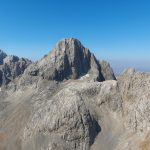
Rimo I, with an elevation of 7,385 meters (24,229 feet), is the highest peak in the Rimo massif, a subrange of the eastern Karakoram Mountains located in the remote northeastern region of Ladakh, India. Positioned near the eastern side of the Siachen Glacier, Rimo I holds strategic and geographical importance but remains one of the least-climbed high-altitude peaks in India due to its isolation, logistical challenges, and restricted access. Mount Rimo I: Peak of the Karakoram
Geographical Location and Terrain
Rimo I is located northeast of the Nubra Valley and lies close to the disputed borders between India and China. It is part of the larger Karakoram range, renowned for hosting some of the world’s highest and most technically demanding mountains. The massif is heavily glaciated and surrounded by several large glaciers, including the Rimo Glacier, Kichik Kumdan Glacier, and Chong Kumdan Glacier.
The terrain of Rimo I is characterized by steep ice faces, exposed rocky ridges, serac fields, and extensive crevassed zones. Climbers must navigate a mixture of glacial travel, technical ice climbing, and unstable snowfields, often under harsh weather conditions. Its geographical remoteness significantly increases the complexity of any expedition planning.
Climbing History
The first successful ascent of Rimo I was accomplished in 1988 by an Indo-British expedition led by Harish Kapadia. The expedition followed the southern approach via the Rimo Glacier and negotiated steep and complex terrain to reach the summit. Since then, the mountain has seen very few ascents due to the administrative restrictions and the significant logistical efforts required to reach its base.
Technical Challenges
Climbing Rimo I demands a high level of technical proficiency in mixed snow, ice, and rock climbing. The standard approach requires teams to cross heavily crevassed glaciers, ascend steep 50–70° snow and ice faces, and traverse narrow, corniced ridges.
Other technical difficulties include:
-
Navigating through heavily fractured glacier fields.
-
Managing avalanche-prone slopes, especially after fresh snowfall.
-
Exposure to sudden storms, high winds, and rapid temperature changes at high altitudes.
-
The necessity for fixed rope installations on steep or unstable sections.
Given the mountain’s remoteness, self-sufficiency is mandatory, as no rescue operations or established support infrastructure exist in the region.
Access and Permits
Access to Rimo I is highly restricted. Expeditions require multiple levels of clearance from Indian military and governmental authorities, as the peak lies in a sensitive border area. Special inner-line permits and Defense Ministry approvals are mandatory.
The journey to base camp involves several days of trekking from the last motorable point, typically starting from Sasoma or Warshi villages near the Nubra Valley. Pack animals or porters are used for transporting supplies over challenging high-altitude terrain.
Climbing Season and Conditions
The optimal climbing season is July to September, coinciding with relatively milder weather conditions in the Karakoram. However, climbers must be prepared for sudden storms, whiteouts, and extreme cold even during the summer months.
Acclimatization is crucial due to the peak’s high altitude and the strenuous glacier crossings during the approach. Teams are advised to schedule gradual altitude gains and maintain flexible itineraries to account for weather delays.
Scientific and Strategic Importance
Beyond mountaineering, Rimo I holds scientific significance as it lies near critical glacial systems that feed into key river basins in the region. The area is also of strategic interest to the Indian military, contributing to its restricted status.
Conclusion
Rimo I represents one of the most remote, technically demanding, and logistically complex climbing objectives in the Indian Himalayas. Reserved for highly experienced mountaineers with strong expedition planning capabilities, Rimo I remains an elusive and formidable challenge in the eastern Karakoram.
Where is Rimo I located?
What is the elevation of Rimo I?
When was Rimo I first successfully climbed?
What are the main technical challenges of climbing Rimo I?
What is the standard climbing route on Rimo I?
Is climbing Rimo I open to foreign climbers?
What skills are required to attempt Rimo I?
When is the best time to climb Rimo I?
How accessible is Rimo I’s base camp?
Why is Rimo I considered significant despite limited ascents?