Mount Bozdag (Ancient Tmolus Mountain): The Highest Mountain in Izmir
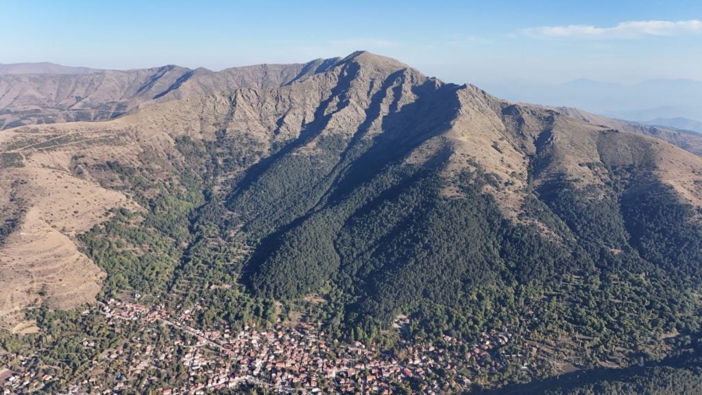
Mount Bozdag (Ancient Tmolus Mountain) is a mountain located 22 kilometers north of Ödemiş district in İzmir, with an elevation of 2,159 meters. The village of Bozdağ, named after the mountain, is a charming settlement situated at an altitude of 1,150 meters. The name Bozdağ comes from one of the highest mountains in Western Anatolia.
Nestled among oak and pine forests, the village of Bozdağ is a paradise with its lush nature and pristine air. The fountain and its surroundings in Mermeroluk within the forest serve as a significant recreational area. The plateau is a popular destination for climbers and nature enthusiasts throughout the year. Additionally, the favorable climate conditions have made Bozdağ one of Turkey’s important paragliding centers.
Bozdağ attracts the most visitors during the summer season with picnic areas like Çınarlı Park, Mermer Oluk, Şelale Park, and Kirk Çeşme. This significantly contributes to the local economy.
It is known that during his princely years, Sultan Mehmed the Conqueror visited Bozdağ and took lessons from his teacher, Molla Gürani, in Çınarlı Park, named after its centuries-old plane trees. The village also contains the ruins of an ancient madrasa.
The cemeteries named Üçler, Beşler, Yediler, and Kırklar indicate that Bozdağ’s history dates back to ancient times. The city was founded by the Lydians in antiquity and was known as Tmolos. Due to its geographical location, it is believed to have served as a garrison during that period. After the Lydians, Bozdağ came under Persian control along with Birgi.
Climbing Routes in Bozdağ
Bozdağ has multiple climbing routes. The most commonly used is the southern classic route, which starts at about 1,000 meters above the village to reach the summit. The walk begins in the forest and continues with excellent scenery and experiences.
The Dik Deresi route carries avalanche risks in the winter months and is not recommended during this season. There are routes from the ski center and the eastern-southeastern regions, but these are not frequently used.
Bozdağlar, High Mountain Ranges of Western Anatolia
The Bozdağ mountain range consists of the high mountains of Western Anatolia, located in İzmir, Manisa, and Aydın provinces. In ancient times, it was known as Tmolos. The Bozdağ range extends east-west for 170 kilometers between the Küçük Menderes and Gediz plains and hosts many endemic plant species.
Starting from the ridges of Buca in İzmir province, it continues between Kemalpaşa and Bayındır districts and then expands between Turgutlu, Salihli, Alaşehir, Ödemiş, Kiraz, and Nazilli.
It hosts many significant peaks, including Kemalpaşa-Nif Mountain, Armutlu-Mahmut Mountain, and Ödemiş-Bozdağ. Bozdağ, at 2,159 meters, is the third highest peak in the Aegean region, after Honaz Mountain and Murat Mountain.
It begins from the ridges of Buca district in İzmir, mostly appearing as small hills. It continues to the region of Torbalı and Kemalpaşa districts without any significant elevation.
After this area, it rises suddenly to form Nif Mountain, which has an elevation of 1,509 meters. Nif Mountain is located in a water-rich area. The Nif and Fertek streams partly originate from this mountain.
After Nif Mountain, the 450-meter high Karabel Pass comes next. Following this, Mahmut Mountain rises suddenly to 1,470 meters. The Kurudere and Fertek streams originate from Mahmut Mountain. After this mountain, the elevation rarely drops below 1,000 meters.
Next comes the Cınardibi Plateau at 700 meters. Following this is Oren Hill, with an elevation of 1,300 meters. From Oren Hill, the Kamberler stream flows north, and the Uladı stream flows south. This area features Kamberler Plateau, known for its rich water resources.
Next is the Alan Kıyı Plateau, a suitable area for picnics. There is not much significant elevation in this area. However, on the Turgutlu side, Dededağ rises impressively at 1,450 meters. Here, Ovacık Plateau, famous for its forests, is located. North of this region flows the Akşar stream, and south flows the Ergenli stream. Directly opposite this mountain is Gökgedik Hill, at an elevation of 1,250 meters. The Çatmadağ, situated between the Ergenli and Falaka streams, stands at 1,470 meters.
This area features much larger plateaus than previous regions, with more than five villages in the Dağmarmara area. North flows the Çıkrıkçı stream, while south flows the Falaka and Aktaş streams. The average elevation here is 700 meters, with intensive cherry farming. The wide plateaus of Bozdağ are located in this area. The Ovacık Plateau and Gencer Plateau are subsequently reached.
Behind Ovacık Plateau lies Keldağ, rising to 1,372 meters. Keldağ is a very pointed and dominant peak in the region and is quite majestic.
Behind Keldağ lies the vast Horzum Plain. From this area, the Kelebek stream flows north, and the Rahmanlar stream flows south. The Kelebek stream is a large stream. Meanwhile, Çamyayla and Başova Plateaus are found here.
After this region come Subatan Plateau, Ayvacık Plateau, Kılıç Plateau, and Artıcak Plateau. Subatan and Ayvacık sinks are worth examining. From this area, the Sart stream flows north.
Next is Gölcük Sırtlanbayırı at 1,450 meters. It is well-known for the Gölcük Plateau and Gölcük Lake. The plateau is very suitable for climbing, picnicking, and photography. It is one of the two plateaus with accommodation facilities. The location of Gölcük Lake has been determined due to tectonic events. However, the lake is a landslide dam lake.
The plateau is the largest on the Bozdağ mountains, with an elevation of 1,050 meters. The Tabak stream flows north, and Çaldağı is located to the east, rising to 1,670 meters.
After this mountain comes Bozdağ Plateau, which is 1,050 meters high.
How to Reach Bozdağ?
To reach Bozdağ village, the closest settlement to the mountain peak at 1,150 meters, two separate routes can be taken from İzmir. The first route is through Ödemiş district, to which the village is administratively connected. Since it is in the south, this road, which is likely to be open in winter, leads to Bozdağ via Birgi, a historical settlement, and the dam lake Gölcük. The northern route, which often closes due to freezing in harsh winter conditions, reaches Bozdağ via Salihli.
There are two different routes to reach Bozdağ from İzmir. They are:
İzmir – Kemalpaşa – Turgutlu – Sart – Bozdağ road (110 km)
İzmir – Torbalı – Bayındır (or Tire) – Ödemiş – Birgi or Gölcük – Bozdağ road (130 km)
The distance between Bozdağ and Ödemiş is 29 km.
Bozdağ Tourism
On the Salihli-Ödemiş road, there is a natural resting area called Kırkoluklar. It features drinkable, cold, and tasty water flowing from about 40 channels built as a charity, a stream located just behind the channels, a lush view of Bozdağ, and pavilions selling local products (such as Bozdağ thyme honey, linden honey, etc.). The location was changed in July 2016.
Bozdağ attracts the most interest during the summer season with picnic areas like Çınarlı Park, Mermer Oluk, Şelale Park, and Kirk Çeşme. This significantly contributes to the local economy.
With its geographical location featuring extensive forested areas, natural beauty, and picnic and recreational areas within the town, Bozdağ is a focal point for both domestic and foreign visitors. Additionally, the opening of the Bozdağ Ski Center, considered the Uludağ of the Aegean, has made the region an attraction.
Bozdağ also has suitable geographical conditions for paragliding. Paragliding enthusiasts particularly show intense interest in the town during the spring and summer months.
Mount Bozdağ Ski Center
The Mount Bozdağ Ski Center, which is open for tourism in winter seasons, was opened in 1998. The facility can serve over 15,000 visitors on holiday weekends. It features three ski areas catering to both professional and amateur skiers. The facility includes a 60-bed hotel, restaurant, cafeteria, and observation balconies. The ski facility may not operate during times when there is no snowfall.
Please click to learn Mount Bozdağ weather conditions instantly from the Snow Forecast website.


